NKVE Shah Alam–Subang Flooded Again, All Lanes Closed
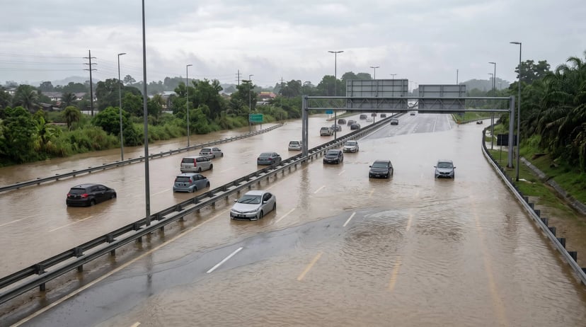
Flash floods have forced the closure of all lanes along the New Klang Valley Expressway (NKVE) between Shah Alam and Subang in both directions on November 4, 2026, following heavy overnight rainfall. Motorists are being diverted to alternative routes, while several nearby highway connections have also been affected.
The closure has disrupted morning traffic across the Klang Valley, particularly for motorists travelling between Shah Alam, Subang, Bukit Raja and Setia Alam.
Table of Contents
Key Takeaways
- All lanes at KM9.1 of the NKVE between Shah Alam and Subang were reported impassable in both directions.
- Northbound traffic from Bukit Raja is being diverted towards Setia Alam.
- Southbound traffic from Subang is being diverted to the ELITE Highway.
- Several connections around the Shah Alam Interchange and Guthrie Corridor Expressway (GCE) are also affected.
- Motorists should check the latest highway updates and avoid driving through floodwaters.
What Happened Along the NKVE?
Heavy rainfall that continued past midnight on November 4 caused flash floods along several major roads in Shah Alam, including the NKVE.
According to PLUS Malaysia Berhad (PLUS), the affected section is located at KM9.1 between Shah Alam and Subang. Floodwaters made the stretch impassable, forcing the highway operator to close all lanes in both directions.
The latest update reported by Paul Tan on November 4 at 8.47am confirmed that the affected NKVE stretch remained closed to traffic.
The flooding also affected surrounding highway connections, creating additional disruption for motorists travelling through Shah Alam and nearby areas.
Motorists should note that highway conditions can change as floodwaters recede. The reported closure status should not be treated as confirmation of the current situation without checking the latest announcements from PLUS.
Which Highway Routes Are Affected?
The flooding has affected several important highway connections around Shah Alam, making it difficult for motorists to travel through the area.
1. NKVE at KM9.1 between Shah Alam and Subang
All lanes in both directions were reported closed due to rising floodwaters. Vehicles could not pass through the affected section.
2. Shah Alam Toll Plaza entrance
PLUS also reported flooding affecting the approach to the Shah Alam Toll Plaza, resulting in lane closures and traffic diversions.
3. Shah Alam Interchange on the ELITE Highway
The interchange connecting Seafield towards Setia Alam was also affected by flooding. However, subsequent updates reported that the affected lanes reopened at 6.43am.
4. Guthrie Corridor Expressway (GCE) connection
The route from the Guthrie Corridor Expressway towards the Shah Alam Toll Plaza was also reported closed due to floodwaters.
5. NKVE interchange ramps
PROLINTAS GCE reported that Ramps B, C and D at the NKVE interchange were closed following flash floods reported at approximately 5.42am.
Where Are Traffic Diversions?
Motorists travelling through the affected areas should follow the temporary traffic diversions introduced by PLUS.
Northbound traffic from Bukit Raja
Vehicles travelling northbound from Bukit Raja are being diverted towards the Setia Alam Toll Plaza.
Southbound traffic from Subang
Motorists travelling southbound from Subang are being diverted towards the ELITE Highway.
Traffic from Seafield towards Setia Alam
Motorists should refer to the latest PLUS announcements, as the Shah Alam Interchange section on the ELITE Highway was subsequently reopened following the earlier flooding.
Traffic from GCE towards Shah Alam
The connection towards the Shah Alam Toll Plaza was reported closed. Motorists should follow the alternative routes and directions provided by highway personnel.
These diversions may increase travel times, particularly during morning and evening peak hours. Motorists are encouraged to allow additional time for their journeys.
What Should Motorists Do During Flash Floods?
Flash floods can develop quickly, especially after prolonged or heavy rainfall. Motorists should prioritise their safety rather than attempting to reach their destinations through flooded roads.
1. Avoid flooded roads
Never attempt to drive through floodwaters, even if the water appears shallow. Water levels can be difficult to judge, and strong currents may affect vehicle stability.
2. Follow official traffic diversions
Pay attention to temporary road signs, electronic message boards and instructions from highway personnel. Do not attempt to enter closed sections.
3. Check traffic conditions before leaving
Check live traffic information and highway announcements before starting your journey. This can help you identify road closures and avoid unnecessary delays.
4. Keep a safe distance from other vehicles
Wet roads reduce tyre grip and increase stopping distances. Maintain a greater following distance to give yourself more time to react.
5. Postpone non-essential journeys
If your route is severely affected by flooding, consider delaying your journey until conditions improve.
Expert Tip
Before driving through an area affected by heavy rain, check traffic cameras and official highway announcements. A navigation application may suggest an alternative route, but always confirm that the alternative road is safe and passable before proceeding.
Common Mistake
Do not assume that a flooded road is safe to cross simply because other vehicles are attempting to pass through it. Water can hide potholes, damage vehicle components or cause an engine to stall. Turn around and find a safer route instead.
How to Check Traffic and Flood Updates
Motorists travelling around Shah Alam, Subang and the Klang Valley should monitor traffic conditions before and during their journeys.
Here are several ways to stay informed:
1. Follow PLUS traffic announcements
PLUS shares highway closures, traffic diversions and road condition updates through its official communication channels, including its X account, @plustrafik.
2. Check highway traffic cameras
Live traffic cameras allow motorists to observe road conditions before entering busy or flood-prone highway sections.
3. Use the Motorist App
The Motorist App provides access to live traffic cameras and traffic updates, helping motorists monitor road conditions and plan their journeys more carefully.
Drivers can check major highway routes, including the NKVE, before deciding whether to travel or consider another route.
However, always refer to official highway announcements for confirmed road closures and reopening information.
4. Contact PLUS for highway assistance
Motorists requiring highway assistance can contact PLUSLine at 1-800-88-0000.
Frequently Asked Questions
1. Is the NKVE between Shah Alam and Subang closed?
According to the November 4 morning updates, all lanes at KM9.1 in both directions were closed due to flash floods. Check PLUS for the latest reopening status.
2. Which part of the NKVE is flooded?
The affected section is KM9.1 between Shah Alam and Subang, where floodwaters made the highway impassable.
3. Where are northbound NKVE motorists being diverted?
Northbound traffic travelling from Bukit Raja is being diverted towards the Setia Alam Toll Plaza.
4. Where should southbound motorists from Subang go?
Southbound traffic from Subang is being diverted towards the ELITE Highway.
5. Is the ELITE Highway also affected by flooding?
Yes. The Shah Alam Interchange between Seafield and Setia Alam was affected, although subsequent updates reported that the affected lanes had reopened.
6. Is the Guthrie Corridor Expressway affected?
Yes. The connection from GCE towards the Shah Alam Toll Plaza was reported closed due to flash floods.
7. Can I drive through shallow floodwater?
No. Even shallow-looking floodwater can cause an engine to stall or a vehicle to lose control. Avoid entering flooded roads.
8. Where can I check the latest NKVE traffic updates?
Motorists can follow PLUS Malaysia's official traffic updates on X through @plustrafik and check its other official communication channels.
9. What should I do if my car gets stuck in floodwater?
Prioritise your safety, avoid attempting to restart a flooded engine and seek emergency or roadside assistance when it is safe to do so.
10. Can the Motorist App help me avoid flooded roads?
The Motorist App provides access to traffic cameras and traffic updates, helping drivers monitor road conditions before travelling. Always verify road closures through official highway announcements.
Conclusion: Check Before You Travel Through Shah Alam
The flash floods along the NKVE between Shah Alam and Subang have disrupted several major highway connections, forcing traffic diversions and affecting motorists travelling through the Klang Valley.
With heavy rainfall potentially causing further disruptions, drivers should avoid flooded roads, follow official traffic instructions and check the latest highway conditions before setting off.
Stay informed and plan your journeys more carefully with the Motorist App, where you can access traffic cameras and updates to help you make better driving decisions.
Read More: Heavy rain alert: how to use Motorist Malaysia traffic cameras to avoid flooded roads [2026 edition]
I want to find the highest selling price for my car within 24 hours!
Download the Motorist App now. Designed by drivers for drivers, this all-in-one app lets you receive the latest traffic updates, access live traffic cameras, and manage vehicle-related matters.


