NKVE Shah Alam Floods Again: Sungai Damansara Project Due 2031
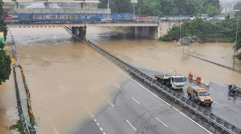
The flood-prone NKVE stretch between Shah Alam and Subang has flooded twice within three days, while the Sungai Damansara flood mitigation project is currently scheduled for completion in July 2031. Prime Minister Anwar Ibrahim has ordered the government to speed up flood mitigation works following the repeated flooding.
Table of Contents
- What happened to the NKVE in Shah Alam?
- Why does the area keep flooding?
- What is the Sungai Damansara flood mitigation project?
- When will the flood mitigation project be completed?
- What measures are being taken in the meantime?
- What should NKVE drivers do during heavy rain?
- Frequently Asked Questions
Key takeaways
- The NKVE at KM9.1 between Shah Alam and Subang flooded twice within three days in early November 2026.
- The Sungai Damansara flood mitigation project is officially scheduled to be completed on July 15, 2031.
- Prime Minister Anwar Ibrahim has ordered work on the Sungai Buloh and Sungai Damansara flood mitigation projects to be accelerated.
- The combined allocation for the two federal flood mitigation projects is nearly RM700 million, with reported progress ranging from 30% to 60%.
- Selangor has allocated an additional RM70 million for 255 immediate flood mitigation projects.
What happened to the NKVE in Shah Alam?
The flood-prone KM9.1 section of the New Klang Valley Expressway (NKVE) in Shah Alam was flooded twice within three days following heavy rainfall.
On November 2, both carriageways between KM9.1 and KM9.4 were closed after heavy rain. At around 4.07am on November 4, all lanes in both directions between Shah Alam and Subang were again reported to be impassable. The affected stretch reopened later that afternoon.
The Shah Alam Toll Plaza and surrounding interchange have also experienced flooding in previous years. The toll plaza was closed by floodwaters in December 2021, while the area around the toll plaza and interchange was affected by flooding again in November 2025.
The repeated disruption is particularly important for motorists because the NKVE is a major route connecting Shah Alam, Subang and other parts of the Klang Valley.
Why does the area keep flooding?
The recent flash floods around the NKVE/Shah Alam toll interchange, Kampung Melayu Subang and Seksyen 13 are located along the alignment of the Sungai Damansara flood mitigation plan.
According to Shah Alam MP Azli Yusof, these locations form part of the area targeted under the flood mitigation plan. The project is intended to improve the river and drainage system and reduce the severity of flooding in flood-prone areas.
The wider Sungai Damansara system runs through areas including Shah Alam before eventually joining the Klang River at Batu 3. This means improvements to the river and its tributaries are expected to benefit several surrounding areas.
However, the project is still being implemented in stages, meaning motorists may continue to encounter flood-related disruptions while the works are ongoing.
What is the Sungai Damansara flood mitigation project?
The Sungai Damansara flood mitigation project involves multiple infrastructure improvements designed to increase the area's ability to manage heavy rainfall and excess water.
The project includes upgrades to the main drainage and river system, a detention pond, pump station, flood bunds, flood walls, parapet walls and a flood drainage system.
Other planned works include drainage outlets installed through pipe jacking, a flap gate at the mouth of Sungai Air Kuning and gross pollutant traps.
The river will also be deepened, with works carried out in stages from upstream across the Petaling and Shah Alam districts.
Kampung Melayu Subang is part of the project alignment, with frequently flooded roads such as Jalan Merbau, Jalan Tembusu and Jalan PKNS among the areas targeted by early mitigation works.
TTDI Jaya, Bukit Jelutong and Seksyen 13 are also expected to benefit from improvements to the river and its tributaries.
Separately, the Selangor state government is funding an RM8.05 million project on Anak Sungai Damansara. The project includes a pump house, flood wall and upgraded outlet structures and drains, with the aim of reducing flash floods around the Subang-Shah Alam border.
When will the flood mitigation project be completed?
According to Selangor state assembly documents, the Sungai Damansara flood mitigation project began on October 16, 2024 and is officially scheduled for completion on July 15, 2031.
However, there are different completion timelines being reported. Ramanan, who previously served as Sungai Buloh MP and is now the human resources minister, had said both phases of the Sungai Buloh and Sungai Damansara projects were expected to be completed by 2029.
The projects are being carried out in two phases and have a combined allocation of nearly RM700 million. Their reported progress currently ranges from 30% to 60%.
Following the latest flooding, Prime Minister Anwar Ibrahim ordered the works to be accelerated. He specifically called for river dredging works, which already have awarded contracts, to be expedited. He also said rivers need to be widened and more retention ponds constructed.
Expert Tip
If you regularly use the NKVE through Shah Alam, check the latest traffic and road-condition updates before leaving, especially when heavy rain is forecast. Flood conditions can change quickly even after a route has reopened.
What measures are being taken in the meantime?
While the larger flood mitigation projects are being completed, the government is also considering several short-term measures to reduce the impact of flooding.
One proposal is a temporary retention pond for Sungai Buloh, estimated to cost RM12 million. The aim is not to eliminate flooding completely but to reduce the severity of flooding currently affecting the area.
In Kampung Melayu Subang, where at least 92 homes were affected by the November 2 floods, the lower sections of the Sungai Pelempas embankments are proposed to be raised by between 0.5 metres and 1 metre. The proposed works are expected to cost less than RM1 million.
Selangor has also allocated an additional RM70 million for 255 immediate flood mitigation projects. These include installing pumps, clearing drains and repairing riverbanks. According to the state infrastructure exco, 177 of the projects have been completed.
The state government is also reviewing other interim measures and potential quick solutions for newly identified flood-prone locations.
Common Mistake
Do not assume that a road is safe simply because other vehicles are still using it during a flood. Floodwater can hide potholes, damage road surfaces and cause a vehicle to lose traction or stall. If a road is flooded or officially closed, use an alternative route.
What should NKVE drivers do during heavy rain?
Motorists travelling through Shah Alam and Subang should be prepared for sudden changes in road conditions when heavy rain hits the Klang Valley.
Before starting a journey, check the latest highway traffic updates and look for reported closures or diversions. This is particularly important when travelling through known flood-prone sections of the NKVE.
If you encounter floodwater ahead, do not attempt to drive through an area that appears unsafe. Turning around and finding a safer route is preferable to risking vehicle damage or becoming stranded.
Drivers should also maintain a greater following distance on wet roads because reduced tyre grip can increase stopping distances.
The Malaysian Meteorological Department has warned that rainfall exceeding 100 mm could continue across the Klang Valley during afternoons until the weekend. Motorists should therefore remain alert to changing conditions.
Frequently Asked Questions
1. Why is the NKVE between Shah Alam and Subang flooding?
The NKVE's flood-prone section is located within an area covered by the Sungai Damansara flood mitigation plan, where major river and drainage improvements are still being carried out.
2. Which part of the NKVE was flooded?
The affected section was around KM9.1, with flooding also affecting the stretch between KM9.1 and KM9.4 and nearby Shah Alam highway connections.
3. How many times did the NKVE Shah Alam section flood in early November 2026?
The flood-prone section was affected twice within three days, on November 2 and November 4.
4. When is the Sungai Damansara flood mitigation project scheduled to finish?
Selangor state assembly documents state that the project is scheduled for completion on July 15, 2031.
5. Could the Sungai Damansara project be completed earlier?
An earlier 2029 completion timeline has been mentioned for the two phases of the Sungai Buloh and Sungai Damansara projects, while the state assembly documents give July 15, 2031 for the Sungai Damansara project.
6. Has the government ordered the flood mitigation works to be accelerated?
Yes. Prime Minister Anwar Ibrahim ordered work on the Sungai Buloh and Sungai Damansara flood mitigation projects to be sped up following repeated flooding.
7. How much money has been allocated for the two federal flood mitigation projects?
The two projects being carried out in two phases have a combined allocation of nearly RM700 million.
8. What short-term flood measures are being considered?
The government is considering a temporary RM12 million retention pond for Sungai Buloh, while additional works include raising embankments, installing pumps, clearing drains and repairing riverbanks.
9. What should drivers do when the NKVE is flooded?
Drivers should avoid flooded or closed sections, follow official traffic diversions and check the latest highway updates before travelling.
10. Can drivers check traffic conditions before using the NKVE?
Yes. Drivers can check traffic updates and live traffic cameras before travelling to help identify congestion, closures and potentially affected routes.
Conclusion: NKVE Drivers Should Stay Alert During Heavy Rain
The repeated flooding of the NKVE between Shah Alam and Subang highlights the ongoing flood risks faced by motorists in the area. While the Sungai Damansara flood mitigation project is expected to deliver longer-term improvements, the current official completion date extends to July 2031.
With the government now pushing for the flood mitigation works to be accelerated and additional short-term measures being considered, drivers should continue to monitor road conditions and avoid flooded routes whenever possible.
Stay informed about changing road conditions with the Motorist App and plan your journey before heading out.
Read More: NKVE Shah Alam–Subang Flooded Again, All Lanes Closed
Want to sell your car? Get a better price with Motorist and enjoy a simple, hassle-free selling experience.
Download the Motorist App now. Designed by drivers for drivers, this all-in-one app lets you receive the latest traffic updates, access live traffic cameras, and manage vehicle-related matters.


